
Showing posts with label weather. Show all posts
Showing posts with label weather. Show all posts
Monday, June 12, 2017
Will You Be in the Path of Totality?
It's coming. There's nothing you or anyone can do about it. On August 21, the Great American Eclipse will arrive. It will be the first coast-to-coast total eclipse since 1918, and the first time since 1252 with a "path of totality" that will only exist here in the continental US.
The "path of totality" is about a 70-mile wide stretch of land, extending from Oregon to South Carolina, where there will be a total eclipse. Here in the Lehigh Valley, a partial eclipse will occur.
Chances of best weather are in the western US.
Thursday, January 21, 2016
NorCo Chief Deputy Sheriff Warns of Snow Cancellation
Northampton County Chief Deputy Chris Zieger, like any committed public safety official, has been tracking the impending snow storm, and has issued a warning to his son that there will likely be no school this weekend, on either Saturday or Sunday.
Monday, July 20, 2015
Heat Causes Bethlehem To Close Tennis Courts, Reduce Pool Fees
Bethlehem's tennis courts are closing today because of the heat. But on the bright side, kids (under 17) can go swimming today for just $2, with adults being charged only $3.
At Allentown's Irving pool, it is just $1.
At Allentown's Irving pool, it is just $1.
Thursday, June 18, 2015
Flash Flood Warning: Bethlehem Tp Closes Farmersville Road
An anonymous source reports that Farmersville Road is closed between the Green Pond country Club entrance and Notre dame High School, due to flash flooding. If that road is out, I suspect others may be in trouble. I have NOT confirmed this report, but am passing it along so you exercise caution. If stuck somewhere, do NOT get out of your car. Do not go in water if you have ANY uncertainty as to its depth.
Monday, June 08, 2015
Is This on I-78?

In a word, No. A friend of mine posted this, claiming it was a picture of a tornado on I-78. It is a picture of a tornado, but it's in Alabama
Tuesday, January 27, 2015
Eastern Pa. Weather Authority: "We Blew the Call"
At this time yesterday, Eastern Pa. Weather Authority was predicting a blanket of 9-14" of snow by this time today. I am delighted to report they got it wrong. Here's their explanation.
Updated 1:46 pm. Lehigh Valley With Love published a story entitled "Can We Finally Stop Saying How Great The Eastern PA Weather Authority Is Now?" But blogger George Wacker decided to redact portions "solely on professional courtesy."
This is the first time I ever heard a blogger refer to himself as a professional.
He snidely adds, "[W]e have the original saved if they decide to take the shitty route." But he's already beaten them to it.
We blew the call, and everyone blew it - and amending or lowering your original call is not nailing it either. No one got this right, plain and simple. It reminds us of the March 5-7th, 2001 epic fail "blizzard" that never was - very eerily similar. Everything looked great through early this evening, and then everything took an abrupt turn for the worse. So although we put countless hours of time and effort into this one, we failed. Yes we got and will get snow, but nowhere close to the epic amounts that up until today looked to be spot on. So this is our "man-up" post. It wasn't hyped, it wasn't sensationalized. It was the right call from a physics and forecasting standpoint, but in the end, mother nature humbled us. It is our first large scale blown call by our staff of meteorologists for our coverage area this year, and this one stings a lot. And will continue to sting until the next one we're sure.I don't know about you, but i'll take this kind of failure. We can all breathe a sigh of relief. As Matt Dees asks, "Why complain about a blizzard that didn't happen?"
Updated 1:46 pm. Lehigh Valley With Love published a story entitled "Can We Finally Stop Saying How Great The Eastern PA Weather Authority Is Now?" But blogger George Wacker decided to redact portions "solely on professional courtesy."
This is the first time I ever heard a blogger refer to himself as a professional.
He snidely adds, "[W]e have the original saved if they decide to take the shitty route." But he's already beaten them to it.
Monday, November 24, 2014
Are You Ready For Wednesday?

Map above is from Eastern PA Weather Authority. Unfortunately, they were on the nose last year. I'm still recovering from last Winter. Couldn't come at a worse time, either, for those who are on the road.
Thursday, February 13, 2014
Snowmageddon Cometh: Prepare For Snow Emergencies
8pm Update from EPAWA:
Storm to end between 2-4 AM, with an additional 4-8".2/13, 3PM Update: Get Ready For Round 2!!
 |
| Graph from EPAWA |
I will update this post with relevant information concerning the storm. Please use the comments here to notify readers of problems encountered during the storm.
Update from EPAWA: "Snow will move in from South to North. It is currently just to our south and will continue to spread over the region shortly after 10PM. Further north it may be until after 11PM. The snow will go through the day Thursday with the *possibility* of a lull for Eastern PA into NJ/DE. I say possible as guidance differs on how much of the dry slot works west. The snow will come back in and heavy after this possible lull in the afternoon hours. End time right now looks like 2-4AM Friday."
Tuesday, February 04, 2014
Road Salt Shortage Comes At Bad Time
Last week, I told you that Hanover Township was running low on road salt, and that other municipalities were worried as well. This was before the most recent snowstorm. Late today, an emergency management official advised me that three Northampton County municipalities were, as of late this afternoon, completely out of road salt. Although I know road crews are doing their best to keep the roads safe, I am recommending that you exercise extreme caution during tomorrow's storm, which may include significant ice. Do not assume the roads have been treated.
Thursday, November 08, 2012
Any Suggestions For the Next Zombie Apocalypse?

Don't get me wrong. Local government officials displayed remarkable dedication during a very serious storm. Whether volunteer firefighters, Mayors, County Executives, public works employees, National Guardsmen or emergency management professionals like Bob Mateff, we owe them our gratitude. They saved lives. Not one zombie fatality. But is there anything we can we do to minimize that even more?
One nice thing about a blog is that its interactivity makes it easy to sound off with suggestions or corrections. So if you were the King or Queen of the Lehigh Valley, what would you suggest?
Here's my ideas.
1) Warming stations. - Increase the number of warming and charging stations, trying to use government buildings when feasible. Last Friday, although the Northampton County Courthouse had power, it remained closed. Most of the homes surrounding it had no power or heat. It is the people's building, although there are obvious security concerns. With planning, part of the building could serve as a warming and charging station. It might even be possible to serve some hot food from the cafeteria
2) Undergrounding. - Local government officials, in concert with developers, engineers and the Lehigh Valley Planning Commission, should sit down with PPL and Met Ed and arrive at a plan that will gradually replace overhead power lines with under ground infrastructure. Because of the cost involved, this should be done in a long-range plan.
Current Pennsylvania law requires any new residential development, consisting of five or more contiguous lots, to install underground electrical service and distribution lines. This law should be expanded so that it applies to commercial, industrial and institutional development as well, and should apply to any new residential development, regardless of the number of homes involved. Exceptions to this requirement, based on physical impossibility or undue hardship, could only be granted by the state PUC, and only with the assent of the municipality affected.
In addition to reducing power outages, this would save the municipal expense of trimming trees.
3) The CCC. - A volunteer Civilian Conservation Corps should be established in each municipality. In the event of a power outage, emergency management officials can alert them to go door to door with announcements concerning warming and emergency shelters, and other important information. In addition, they would be charged with the responsibility of checking on elderly community residents.
And watching out for zombies.
Monday, October 29, 2012
For All Your Hurricane Needs
... check out Northampton County Emergency Emergency Management. No bike riding today!
Saturday, March 03, 2012
Pure Evil

Monday, January 23, 2012
Jesus Walked on Water, But I Can Walk on Ice!

You slip them over your running shoes, the way we used to slip chains over tires before front wheel drive became popular.
Will they work in a run? I'll find out soon, although I doubt there'll be much ice today. But that's not the reason for this post.
Many of us manage to hurt ourselves this time of year, just in the simple act of walking to our car during a snow or ice storm. Since these are pretty cheap and easy to use, I'd recommend these for old farts like me, not just athletes.
Saturday, August 27, 2011

Friday, August 26, 2011
Don't Drown, Turn Around
Although Hurricane Irene has weakened, it's clear we're in for heavy rains, starting around noon on Saturday. Northampton County Emergency Management Services has issued an alert, warning about flash floods:
Be advised heavy rainfall caused by Hurricane Irene will likely cause flooding. – including flash flooding. Those living in areas prone to flooding should be prepared to take action. All residents should stay tuned to local media outlets for current conditions and follow instructions given by local emergency officials.
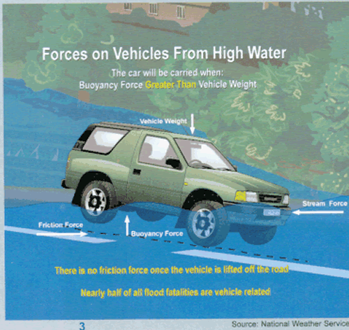
Flash floods are the #1 weather-related killer in the U.S. (Check out this link from NOAA - “Turn Around Don’t Drown”
"A mere six inches of fast-moving flood water can knock over an adult. It takes only two feet of rushing water to carry away most vehicles. This includes pickups and SUVs."

Be advised heavy rainfall caused by Hurricane Irene will likely cause flooding. – including flash flooding. Those living in areas prone to flooding should be prepared to take action. All residents should stay tuned to local media outlets for current conditions and follow instructions given by local emergency officials.
Flash floods are the #1 weather-related killer in the U.S. (Check out this link from NOAA - “Turn Around Don’t Drown”
"A mere six inches of fast-moving flood water can knock over an adult. It takes only two feet of rushing water to carry away most vehicles. This includes pickups and SUVs."
Monday, May 23, 2011
You Don't See This Every Day
 From the National Weather Service:
TORNADO WARNING
BULLETIN - EAS ACTIVATION REQUESTED
TORNADO WARNING
NATIONAL WEATHER SERVICE MOUNT HOLLY NJ
758 PM EDT MON MAY 23 2011
THE NATIONAL WEATHER SERVICE IN MOUNT HOLLY NJ HAS ISSUED A
* TORNADO WARNING FOR...
EAST CENTRAL LEHIGH COUNTY IN EASTERN PENNSYLVANIA...
CENTRAL NORTHAMPTON COUNTY IN EASTERN PENNSYLVANIA...
THIS INCLUDES THE CITY OF EASTON...
EXTREME WEST CENTRAL HUNTERDON COUNTY IN NORTHWEST NEW JERSEY...
SOUTHWESTERN WARREN COUNTY IN NORTHWEST NEW JERSEY...
NORTH CENTRAL BUCKS COUNTY IN SOUTHEAST PENNSYLVANIA...
* UNTIL 830 PM EDT
* AT 754 PM EDT...NATIONAL WEATHER SERVICE DOPPLER RADAR INDICATED A
SEVERE THUNDERSTORM CAPABLE OF PRODUCING A TORNADO NEAR
NORTHAMPTON...OR 8 MILES NORTH OF ALLENTOWN...MOVING EAST AT 20
MPH.
* THE TORNADO WILL BE NEAR...
BATH BY 810 PM EDT...
BETHLEHEM BY 815 PM EDT...
NAZARETH AND 6 MILES NORTH OF HELLERTOWN BY 820 PM EDT...
OLD ORCHARD AND TATAMY BY 825 PM EDT...
GLENDON...WILSON...EASTON AND FORKS BY 830 PM EDT...
PRECAUTIONARY/PREPAREDNESS ACTIONS...
IN ADDITION TO THE TORNADO...THIS STORM IS CAPABLE OF PRODUCING UP
TO TWO INCH SIZE HAIL AND DESTRUCTIVE STRAIGHT LINE WINDS.
WHEN A TORNADO WARNING IS ISSUED BASED ON DOPPLER RADAR...IT MEANS
THAT STRONG ROTATION HAS BEEN DETECTED IN THE STORM. A TORNADO MAY
ALREADY BE ON THE GROUND...OR IS EXPECTED TO DEVELOP SHORTLY. IF YOU
ARE IN THE PATH OF THIS DANGEROUS STORM...MOVE INDOORS AND TO THE
LOWEST LEVEL OF THE BUILDING. STAY AWAY FROM WINDOWS. IF DRIVING...DO
NOT SEEK SHELTER UNDER A HIGHWAY OVERPASS.
THE SAFEST PLACE TO BE DURING A TORNADO IS IN A BASEMENT. GET UNDER A
WORKBENCH OR OTHER PIECE OF STURDY FURNITURE. IF NO BASEMENT IS
AVAILABLE...SEEK SHELTER ON THE LOWEST FLOOR OF THE BUILDING IN AN
INTERIOR HALLWAY OR ROOM SUCH AS A CLOSET. USE BLANKETS OR PILLOWS TO
COVER YOUR BODY AND ALWAYS STAY AWAY FROM WINDOWS.
IF IN MOBILE HOMES OR VEHICLES...EVACUATE THEM AND GET INSIDE A
SUBSTANTIAL SHELTER. IF NO SHELTER IS AVAILABLE...LIE FLAT IN THE
NEAREST DITCH OR OTHER LOW SPOT AND COVER YOUR HEAD WITH YOUR HANDS.
Because I have Tiger blood, I went outside. To my surprise, there were a few other cRaZies out there.
Wednesday, February 24, 2010
On Eve of Major Snowstorm, LV's NOAA Weather Radio Takes a Powder
Since there's a winter storm warning in effect for the Lehigh Valley, you might want to tune in to NOAA's Weather Radio. But guess what? On the eve of this major weather event, the station is off the air.
NOAA Weather Radio all hazards station khb-38, broadcasting fromAtlantic City, New Jersey on frequency 162.400 mega-hertz is off the air. Technicians have been notified, however, a return to service time is unknown at this time.Doesn't that make you feel nice and secure? Our government would screw up a church picnic.


Subscribe to:
Posts (Atom)